![]() |
BIOMETORE Biodiversity in seamounts: The Madeira-Tore and Great Meteor Physical oceanography dataset |
![]() |
The BIOMETORE project, coordinated by IPMA, has several national and international partners and involves many scientific disciplines. The main goal is to collect information on the NE Atlantic seamounts, namely in and around the ‘Great Meteor’, south of the Azores (in 2015); as well as around the Madeira-Tore seamount chain (in 2016), between the Portuguese mainland and Madeira Archipelago (see maps below). The general objective of the project is to increase the scientific knowledge on the biodiversity and oceanographic characteristics of these regions. Funded by the EEA-Grants, information from this project will be an important contribution to the Marine Framework Directive. |
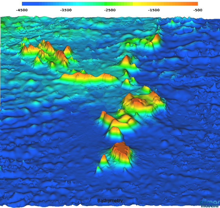
![]() Great Meteor Seamounts |
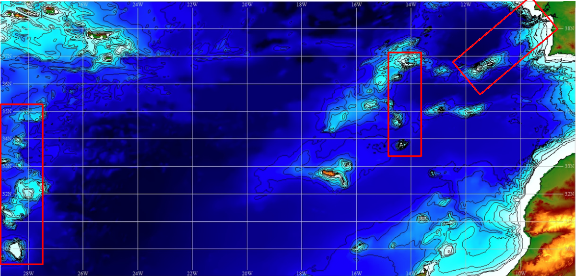
![]() BIOMETORE Regions |
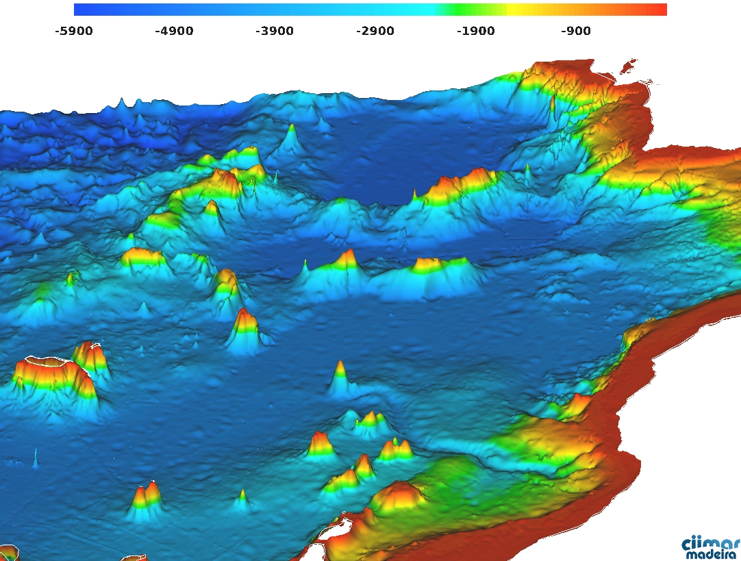
![]() Madeira-Tore Seamounts |
To help plan the oceanographic cruises as well as help the interpretation of other datasets, forecasts (Jun.2013-present) and historical observations (Jan.2013-present) are provided, as planned in Task 3.1 ‘Compilation and analysis of existing data’, as part of Work package 3 – ‘Pelagic habitats characterization’. Rui Caldeira (OOM) and A. Miguel Santos (IPMA) coordinate this task but all partners are invited to contribute / participate. |
Great Meteor | Madeira-Tore | Analysis |
Ocean Circulation Forecasts - Madeira-Tore |
MERCATOR is an operational Global Ocean Circulation product, provided daily by 'myocean'. The PSY2V4R4 is an Atlantic Ocean extraction from the operational Mercator global ocean analysis and forecast system – at 1/12 degree - is providing 7 days of 3D global ocean forecasts updated daily and ocean analysis updated weekly. The 'Atlantic-Iberian-Biscay-Irish' (IBI36) is 5-day hydrodynamic Regional forecast based on a (eddy-resolving) NEMO-model application run at 1/36 degree (~3km) horizontal grid resolution, updated daily. Variables are displayed over the bathymetric lines of 0-2500m (each 250m); Plotted model variables include: i) Sea Surface Height (SSH); ii) Temperature; iii) Salinity; iv) ocean current vectors over flow speed. You can visualize maps in the approximate model-depths: 0,50,100,200,300,500,750,1000,1500,2000,2200 meters. |
PSY2V4R4 | IBI36QV4R1 |
Sea Surface Height | Temperature | Salinity | Speed & Flow |
Depth (m): |
![]() ![]() |
![]() |
![]() |
Previous | Play/Pause | Next |
Satellite Observations - Madeira-Tore |
Satellite derived observations include: i) Sea surface height from AVISO; ii) Sea Level Anomaly (SLA), from AVISO iii) Sea Surface Temperature (SST), extracted from NASA’s ‘Group for High Resolution Sea Surface Temperature' (GHRSST); iv) Ocean Surface Currents derived from satellite altimeter and scatterometer data (OSCAR); v) Monthly averages of Chlorophyll-a derived from daily Level-3 standard mapped image (SMI) with 4.6 km resolution (MODIS-Aqua). |
Sea Surface Height | Sea Surface Temperature | Sea Surface Currents | Sea Level Anomaly | Chlorophyll-A |
![]() |
Previous | Play/Pause | Next |
![]() |
![]() |
![]() |
© 2023 Oceanic Observatory of Madeira Developed by Carlos Lucas |
![]() |